


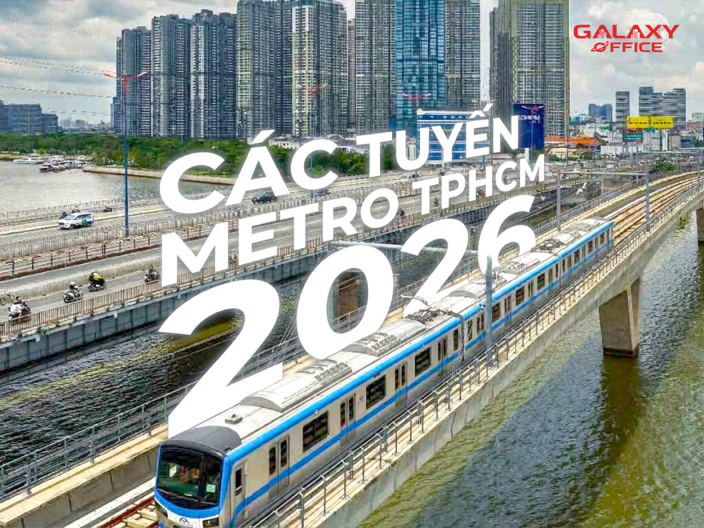
Summary of Metro Line Diagrams Ho Chi Minh City Latest 2026. Roadmap, progress, operating time. Check it out now to get a grasp of the city's most modern transportation system!
Overview of the Ho Chi Minh City Metro System 2026
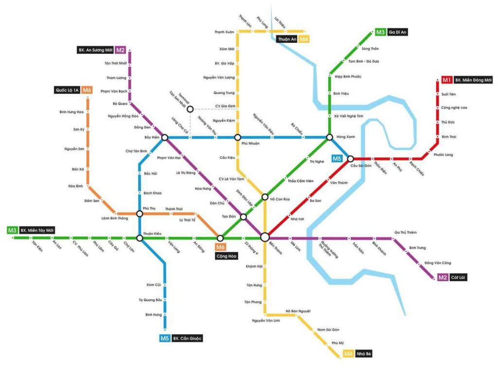
Ho Chi Minh City Metro is a key transportation infrastructure project aimed at reducing traffic congestion. Sustainable Urban Development, including:
- 8 main Metro lines
- 3 auxiliary branches
- Total planned length: over 220 km
- Connection center: Ben Thanh Market area (District 1)
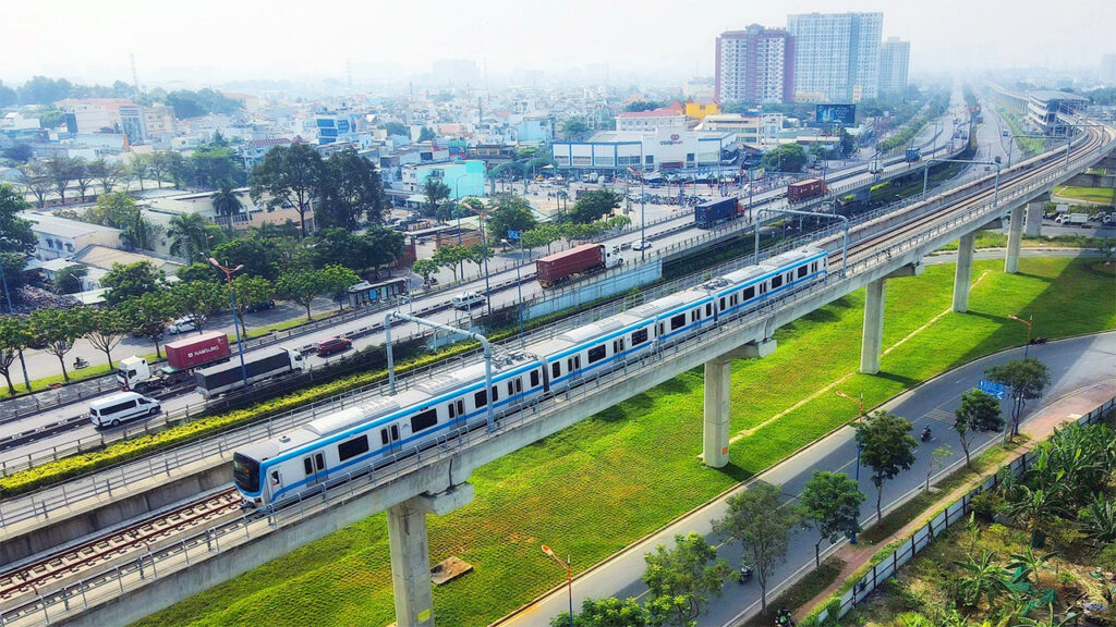
Currently, Metro Line 1 (Ben Thanh – Suoi Tien) is the first line to be completed and put into operation. Stay updated with the latest Ho Chi Minh City metro line map!
Ho Chi Minh City Metro Lines Map – Detailed Update
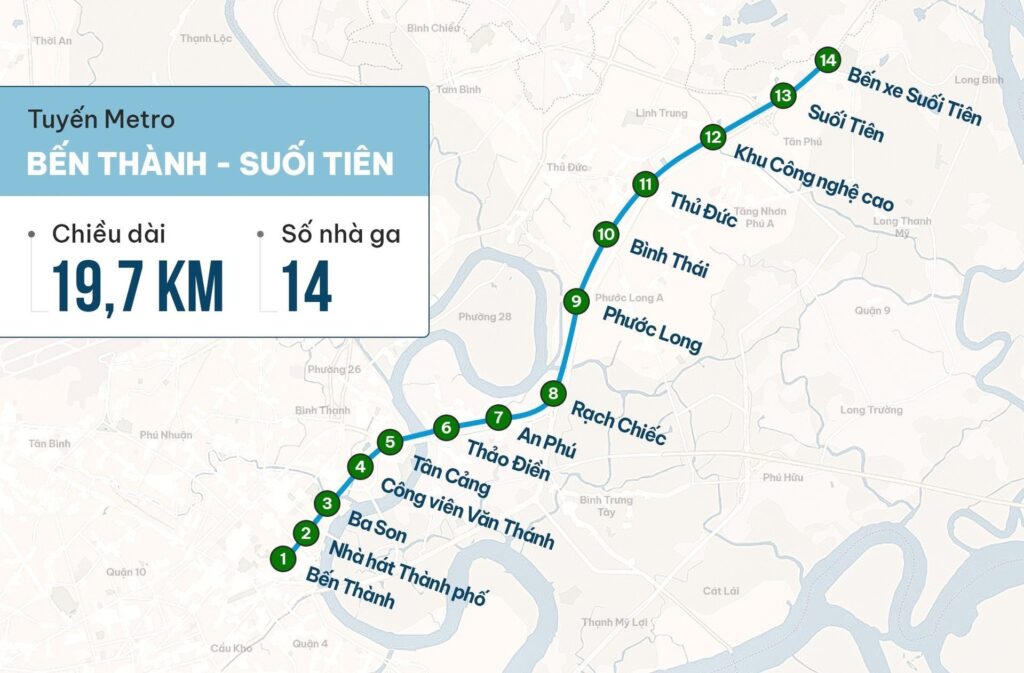
Line 1: Ben Thanh – Suoi Tien
Metro Line 1 is now operational.
- Length: 19.7 km (including 2.6 km underground, 17.1 km elevated)
- Number of stations: 14 stations (3 underground stations, 11 elevated stations)
- Status: Completed, operational since 2025
- Main route: Ben Thanh – City Theater – Ba Son – Van Thanh – Tan Cang – Thao Dien – An Phu – Rach Chiec – Phuoc Long – Binh Thai – Thu Duc – High-Tech Park – Ho Chi Minh City National University – Suoi Tien Bus Station
Highlights: Line 1 connects downtown Ho Chi Minh City with the eastern district (Thu Duc City). It shortens travel time to about 30 minutes.
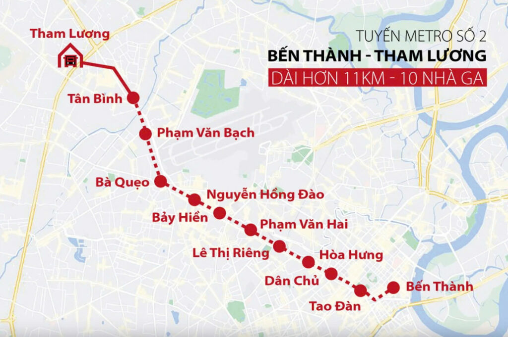
Line 2: Ben Thanh – Tham Luong
Metro Line 2 has just been launched 15/01/2026, with a total investment of nearly 47.9 trillion VND.
- Length: 11.3 km (mainly underground)
- Number of stations: 11 stations (10 underground, 1 elevated)
- Main route: Ben Thanh – Dan Chu – Hoa Hung – Le Thi Rieng – Pham Van Hai – Lang Cha Ca – Bay Hien – Pham Hong Thai – Tan Binh – Tan Phu – Tham Luong
Highlights: Line 2 forms the east-west backbone of the transportation network. It runs underground through the city center.
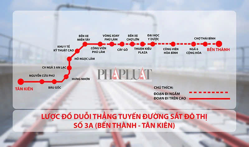
Line 3A: Ben Thanh – Tan Kien
- Length: 19.8 km
- Planned route: Ben Thanh – Ba Thang Hai – Hong Bang – Kinh Duong Vuong – Western Bus Station – National Highway 1A – Tan Kien (Binh Chanh District)
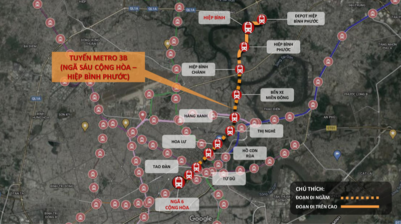
Metro Line 3B Route Map: Cong Hoa – Hiep Binh Phuoc
- Length: 12.2 km
- Planned route: The route of Metro Line 3B starts from Ngã 6 Cộng Hòa, passes through Nguyễn Thị Minh Khai – Xô Viết Nghệ Tĩnh – National Highway 13, and ends at Hiệp Bình Phước Depot Station (Thủ Đức City).
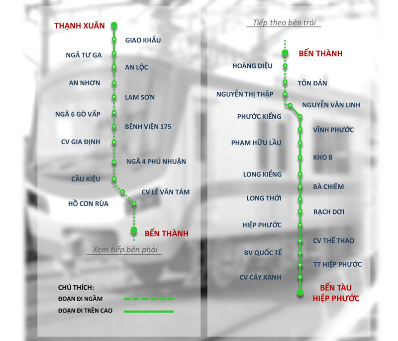
Line 4 Metro Route Map: Thanh Xuan – Hiep Phuoc
- Length: 36.2 km
- Planned route: Thanh Xuan – National Highway 13 – Nguyen Xi – Dinh Tien Hoang – Nguyen Thi Minh Khai – Nguyen Van Cu – Nguyen Van Linh – Hiep Phuoc Urban Area
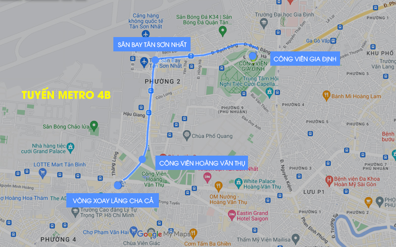
Line 4B Metro Route Map: Gia Dinh Park – Hoang Van Thu Park
- Length: 3.2 km, entirely underground
- Metro Line 4B starts at Gia Dinh Park Station, runs along Nguyen Thai Son – Hong Ha – Tan Son Nhat International Airport – Truong Son – Hoang Van Thu Park, and ends at Lang Cha Ca Station.
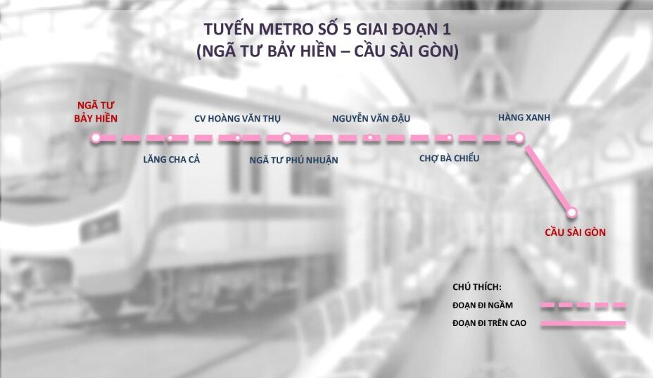
Metro Line 5 Route Map: Bay Hien Intersection – Saigon Bridge
- Length: 23.4 km
- The detailed route is as follows: New Can Giuoc Bus Station – National Highway 50 – Tung Thien Vuong – Phu Dong Thien Vuong – Ly Thuong Kiet – Hoang Van Thu – Phan Dang Luu – Bach Dang – Dien Bien Phu – Saigon Bridge. There are a total of 16 underground stations and 6 elevated stations.
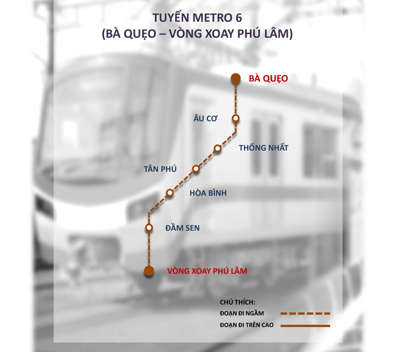
Line 6 metro route map: Dam Sen – Phu Lam
- Length: 6.8 km
- The main route starts from Dam Sen Cultural Park, passes through Ba Queo – Au Co – Luoi Ban Bich – Tan Hoa Dong roads, and ends at Phu Lam Roundabout Station.
Benefits of the Ho Chi Minh City Metro Line
When the Ho Chi Minh City metro system becomes operational, it will bring many benefits to the city, its residents, and the environment. Below are some of the main benefits:
1. Reduce traffic congestion
One of the greatest benefits of the metro system is reducing traffic congestion on roads. Ho Chi Minh City is currently facing severe traffic congestion, especially during rush hour. The metro will help disperse traffic and reduce pressure on main roads, creating smoother flow for other vehicles.
2. Save travel time
With its high speed and ability to operate independently of ground traffic, the metro system will save people a lot of time compared to traveling by car or motorcycle. This is especially beneficial for those who commute long distances and need to travel through congested areas.
3. Improve air quality
Public transportation, especially the metro, typically uses clean energy and causes less air pollution than personal transportation such as motorcycles and cars. Using the metro will help reduce CO2 emissions and contribute to improving air quality in Ho Chi Minh City.
4. Operational cost savings
The metro system will help reduce costs for personal transportation such as gasoline, vehicle maintenance, parking fees, etc. People only need to purchase metro tickets, helping to save money and reduce dependence on personal vehicles.
5. Strengthen economic development
The metro will open up development opportunities for areas adjacent to metro stations. It will drive urban development, leading to the construction of commercial centers., office for rent, and real estate projects. This not only creates many job opportunities but also boosts the city's economy.
6. Developing a modern public transportation system
The implementation of the metro system will also help improve the quality and modernity of public transportation in Ho Chi Minh City. The metro system will replace outdated modes of transportation that do not adequately meet the needs of the people. At the same time, it will provide a more convenient and safer transportation service.
7. Reduce congestion in the central area
By connecting densely populated areas with suburban areas, the metro line will help reduce congestion and disperse people from central areas to the outskirts. This will alleviate overcrowding at locations such as Ben Thanh Market, Tan Son Nhat Airport, etc.
8. Supporting sustainable urban development
The development of the metro system also means that Ho Chi Minh City will move towards a more sustainable urban model. Public transportation is an important part of building a healthy living environment, helping to reduce pollution and create a people-friendly city.
Conclusion
Moving beyond 2026 marks a period of strong economic growth for Vietnam and an important milestone for Ho Chi Minh City's transportation network. With the operation of Metro lines, the city is taking solid steps towards a modern, convenient, and sustainable public transportation system.
Updating the metro route map and tracking progress will help you seize opportunities for faster travel. Make profitable investments in the near future.